What is DMZ in Vietnam?
It no longer exists. But from 1954 until 1975, it was a no-man’s land that divided North Vietnam from South Vietnam at the 17th parallel. When heavy US troops were there during the 1960s, any unfriendly forces in that portion of land would’ve been wiped out. Which is why the north reverted to the Ho Chi Minh Trail instead. This trail (a road network, actually) went around the DMZ and infiltrated into the Army of Vietnam. DMZ=De-Militarized Zone.
Vietnamese demilitarized zone – Establishing the DMZ
1945, when an agreement was drawn up as to how the Japanese should surrender. Vietnam was divided (like Korea) along the 16th Parallel. Japanese troops to the North would surrender to China, and troops to the South would surrender to the United Kingdom. Both countries would send in troops to occupy Vietnam. The British handed the south to the French, and the Chinese made a deal with the French and handed them the north. However, the real division was in 1954 as a result of the Geneva Conference, which was held to discuss how to resolve the war between the French and the communist Viet Minh (led by Ho Chi Minh, who wanted independence). The Viet Minh agreed to withdraw all their forces from south of the 17th Parallel. The French agreed to withdraw all their forces from north of the line. The Geneva Accords said that elections should be held in 1956 for the unification of Vietnam, but the elections ended up being rigged. Vietnam was split into two separate countries as a result.
The northern part of Vietnam was almost entirely controlled by the Viet Minh. The southern part of Vietnam, by the French and allies, and then by the United States in power. The boundary between these two zones was established at the Ben Hai River, which enters the East Sea. The boundary followed the Ben Hai river to its headwaters, about 55 km WSW, and thence to the Laotian border. The area within 5 km on either side of the border was declared to be a demilitarized zone. Troops of both governments were barred from this area.
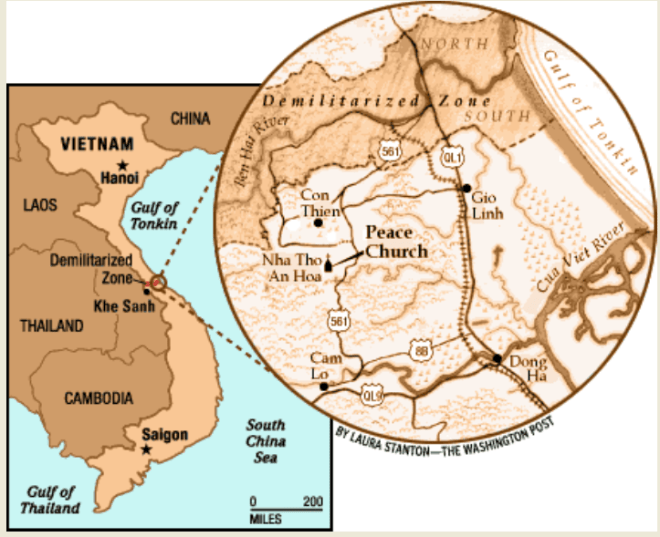
DMZ Vietnam map
The DMZ ran east-west near the center of present-day Vietnam, spanning more than a hundred kilometers and was a couple of kilometers wide. It reached across to a beach on the east. An island nearby was controlled by North Vietnamese forces during the Vietnam War. Although it was nominally described as being at “the 17th parallel,” almost all of the zone lies to the south of the parallel, with only a small portion of the zone near the eastern shore actually including the parallel. It was around 100 kilometers north of the city of Hue. It extended about a mile on either side of the Ben Hai River and ran east to west from the Laos border to the East Sea.
Exploring the Demilitarized Zone can today be comfortably achieved by joining one of the various organized tours starting daily from Hue. Together with a local guide, the most famous war settings, as Khe Sanh Combat Base, The
To explore the De-Limitarized Zone nowadays, let’s find out more about the link to the DMZ tour with us.
